Global maritime domain awareness and vessel analysis
ReleasesLearn about our latest improvements
Arming research analysts with hidden clues to their maritime domain
Global maritime domain awareness and vessel analysis
ReleasesLearn about our latest improvements
Arming research analysts with hidden clues to their maritime domain
The journey of IUU risk indicators from red flags to real-time response
Customer Case Study · 3 April 2023 · 10 minute read
During Operation Nasse 2022 analysts worked collaboratively, uncovering multiple hidden relationships and high risk behaviours, to prioritise vessels for further investigation.
This article is an excerpt from The importance of maritime domain awareness in fighting illegal, unreported and unregulated fishing first published in the December 2022 Pacific Community Fisheries Newsletter. The full article is available for download on the SPC website.
Megan is an analyst at the National Intelligence Unit of the Australian Fisheries Management Authority (AFMA), and her day-to-day role is to uncover the patterns and behaviours of vessels that display risk factors that are consistent with illegal, unreported, and unregulated (IUU) fishing activity. She takes an investigative approach to her analysis, combining as many sources of intelligence as available to gather evidence of vessels that are likely to be engaged in IUU fishing. The more defined the profile of IUU activity becomes, the more targeted enforcement actions can become.
Megan often starts by investigating recorded and real-time ship tracks and identifies movement patterns. Although many movements and characteristics of at-sea activity on their own appear innocuous, patterns and connections over time create a clearer picture of whether a ship is engaged in IUU fishing activities or not.
Indicators that raise red flags include:
- Gaps in the vessel location tracking where positional transponders have been disabled in locations that have a history of IUU fishing;
- Anomalous movement patterns where vessels take unusual diversions or move into an area they are not authorised to fish in; and
- Fishing activity in distant high-sea pockets – areas far from exclusive economic zones that are not covered by any nation’s jurisdiction and are hard for authorities to reach.
She explains that analysing IUU risks is not as simple as evaluating the risk indicators listed above. While the indicators in principle are applicable globally 2, their expression and relative importance vary by region, target species, gear type, and season.
For example, in the western and central Pacific tuna fishery, the biggest IUU fishing risk comes from misreporting (89% of the quantified annual volume of IUU fishing-implicated Pacific tuna harvested or transshipped), while illegal, unlicensed fishing is estimated to account for only 5% 3. Characteristic for this region is the prominence of longline vessels that make up 65% of all active Western and Central Pacific Fisheries Commission (WCPFC) registrations 4. This affects the type of catch, bycatch, and relevant conservation management measures, creating a different risk profile for IUU fishing than, say, a purse-seine vessel-dominated Indian Ocean tuna fishery.
Factors such as climate, economic and market variability also influence the weighting of the risk factors. For example, large scale ocean–atmosphere variations such as the El Niño-Southern Oscillation (ENSO) dictate where target species of fish are found, and volatility in fuel prices determine how much it costs to reach those areas. Therefore, Megan investigates potential recipients of government subsidies that help offset the high costs associated with fishing in high seas waters, where the lack of oversight increases the risk of IUU fishing.
Network analysis as a tool to capture complex relationships
The basic unit for IUU fishing activity is the fishing vessel, but vessels at sea do not operate in isolation. Fleets of ships often fish in the same area, and supply vessels, refrigerated fish carriers, and tankers all form complex interrelationships.
Therefore, Megan is particularly interested in fishing fleets and encounters between vessels at sea because these can sustain a ship’s operation away from ports and regulatory oversight for a long time. This makes time since last port visit and the length of encounters important risk indicators.
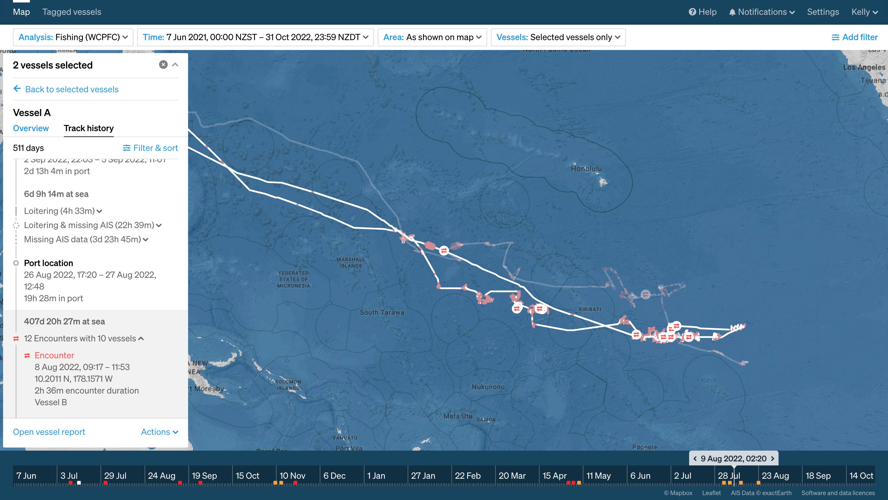
After over 400 days at sea, including fishing in areas of the WCPFC Convention Area, which are generally harder for surveillance to reach, this vessel is returning to port. En route, it encounters another fishing vessel for just over two and a half hours. These potentially high-risk behaviours are clearly identifiable when the extended history of this vessel is visualised.
Megan says that, “When I see patterns where ships are coming together, I want to dig deeper and understand what is happening there. With this type of behaviour, I look at what types of vessels are meeting up, who owns those ships, what is the ownership history, and any historical IUU fishing prosecutions connected to this network. Combining that external information alongside geospatial data will give me a much clearer view of what is going on there.”
Considering encounters with other fishers and support vessels adds a whole new dimension to the problem because the number of ships involved grows exponentially.
| Network analysis as a tool to capture complex relationships |
One tool to help analysts to capture and simplify the complex interconnected web of interactions formed by encounters over time is network analysis. Starboard’s Network analysis allows Megan to look deeper into relationships that may at first be hidden. For example, it allows her to uncover a connection between two vessels of interest that have not had direct encounters, but can have a relationship via a common carrier vessel that encounters with both. Importantly, inspecting encounter networks also allows her to discount connections between certain vessels, so she can focus the time-consuming investigation of onshore networks on high-risk candidate vessels. |
Armed with comprehensive historic and up-to-date vessel tracking information, lists of vessels of good standing and of vessels with a history of IUU fishing, and data science tools, Megan can achieve an effective maritime domain awareness (MDA).
This MDA allows her to provide vital intelligence to direct military and civil assets to targets for boarding, inspection, and prosecution in the field. A prime example where these complex layers of intelligence are woven together to result in operative action is “Operation Nasse” (Op Nasse).
Case study: Operation Nasse 2022
Op Nasse is an annual, multilateral maritime monitoring, control and surveillance (MCS) operation to actively fight IUU fishing in the western and central Pacific Ocean. It is a multilateral effort between Australia, New Zealand, France and the United States. Under the framework of the Pacific Quadrilateral Defence Coordination Group (Pacific Quad), these nations have worked together to conduct Op Nasse on the high seas of the southwest Pacific Ocean each year since 2015, with the United States joining in 2016 5.
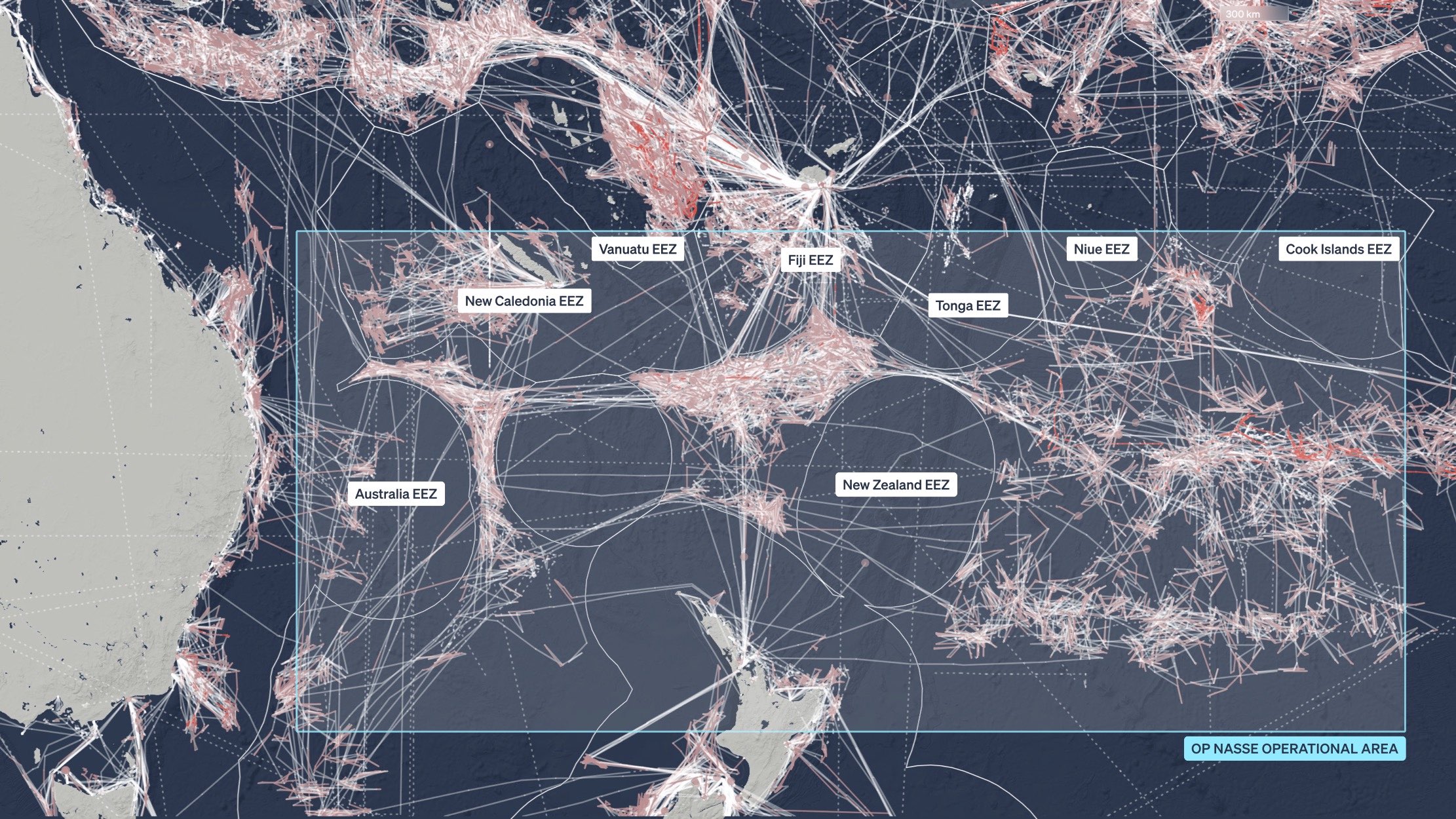
The western and central Pacific with the Op Nasse operational area and national exclusive economic zones. Tracks of 978 fishing vessels from 1 June to 31 July 2022 show intensive fishing activity in the high-seas pockets. Pink tracks indicate active fishing as identified by the Starboard Maritime Intelligence platform’s classification algorithm.
Op Nasse’s aim is to target high-risk fishing vessels for high seas boarding and inspection and aerial surveillance.
The goal of the annual operation is to combat IUU fishing activities and better understand the level of compliance among high seas fishing vessels in respect to the WCPFC conservation management measures. The size of the area of the operation and the remoteness of many parts within it necessitate an intelligence-driven approach with effective information sharing and target priorities between the Pacific Quad partners
During Op Nasse 2022, a joint coordination centre (JCC) was established at the French Armed Forces Headquarters in Noumea, New Caledonia, to coordinate the regional surveillance effort 5. As AFMA’s Senior Intelligence Analyst, Megan Charley developed a significant part of the preoperative intelligence and provided recommendations and intelligence to the JCC for operational response.
Starting with the big picture
Concentrating on the potential of IUU fishing activity in the WCFPC means taking into account over 2700 vessels currently registered and with the authorisation to fish and transship in the region by the WCPFC 4. To reduce the number of vessels to just those with potential IUU fishing risk indicators, Megan began by first analysing key environmental and socioeconomic factors in 2022. Specifically, the ENSO climatic pattern was in the La Niña phase during 2022, with strong surface tradewinds piling up warm water in the western Pacific 6. In La Niña years, tuna catches generally shift from east to west 7.
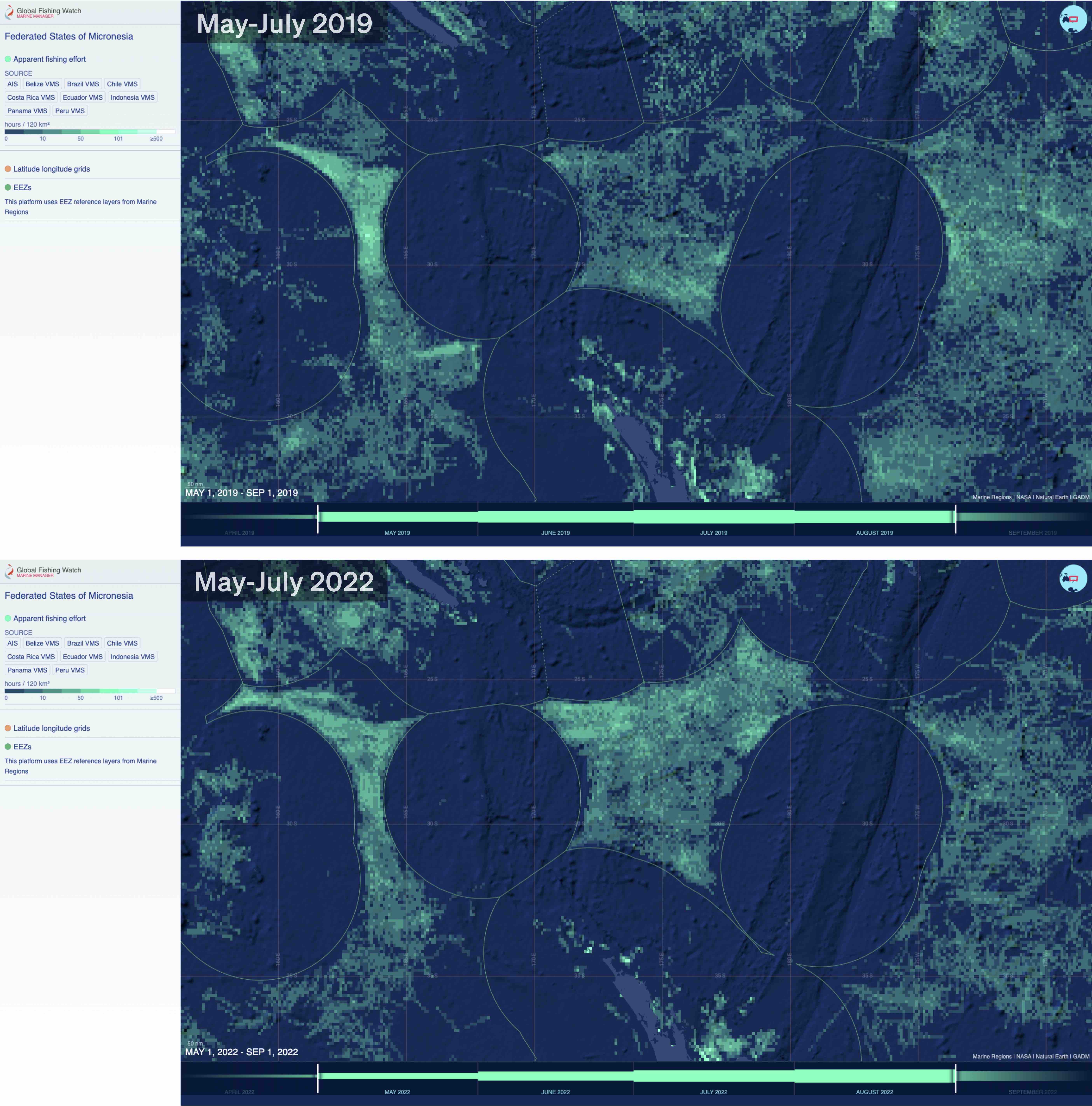
Fishing effort in the western and central Pacific in May–July 2019 (top panel) and the same time period in 2022 (bottom panel) from Global Fishing Watch Marine Manager app. Using such plots, the intensity of distant-water fishing can be correlated against factors such as El Niño-La Niña conditions (2019 versus 2022, respectively) and geopolitical factors.
In addition, Megan focused on distant-water fishing vessels that travel several thousand miles from their home port into remote areas of the Pacific where perceived enforcement efforts may be lower. This may seem a viable business model under government subsidies and reasonable fuel and logistical costs, but the conflict in Ukraine saw fuel prices skyrocketing. As a result, distant-water fishing in the eastern Pacific was likely to incur high operating costs, thus incentivising IUU fishing practices through their potential financial benefit.
Taking into account environmental and geopolitical factors, Megan knew what to look for: a westward shift of fishing vessels that usually target remote areas of the Pacific. She found several such vessels and noticed that their current positions intersected with the Op Nasse area of operations.
Looking deeper into networks
To further validate and prioritise the vessels of interest, JCC analysts investigated several IUU fishing indicators. They sought to identify the beneficial owners, fleet structure, and shareholder networks of the companies, especially where connections may be obfuscated through vague WCPFC records of fishing vessel details, separate ownership listings among shareholders, or using third-party addresses and flags of convenience.
These ownership networks allowed vessels to be grouped into extended fleets that could be analysed for correlations with other potential IUU fishing indicators.
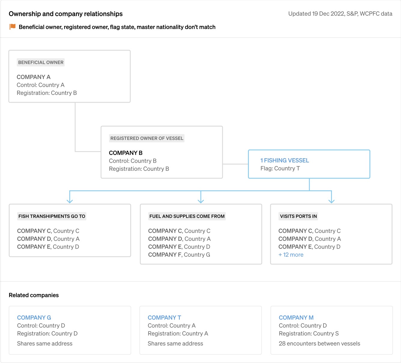
This vessel report prototype from Starboard Maritime Intelligence shows how the inclusion of vessel ownership information in MDA platforms will be able to assist with ownership analysis that incorporates real-time geospatial data.
Geospatial analysis of AIS data was conducted using the Starboard Maritime Intelligence platform to determine the operational patterns of fleets, transshipment indicators, time at sea, port visits, anomalous movements, and WCPFC registration details.
| Notable patterns included: |
Vessels that routinely travel extensive distances to fishing grounds, without any identified record of government subsidies or foreign port use. This apparent uneconomic behaviour is an indicator for potential IUU fishing 8. Vessels that have a history of:
Concerns for crew welfare can be inferred from anomalous movements and encounters. Where vessels appear to behave in an abnormal fashion, this will naturally elevate the risk of IUU fishing activity and forced labour concerns. |
Going even deeper, Megan and the analysis team used publicly accessible information, including non-English sources, to discover potential IUU fishing allegations (among other prosecutions) or prior convictions for the vessels, masters, crew, companies, or shareholders. This investigative research identified some vessels and companies as having both IUU fishing allegations and officially recorded court proceedings in foreign and domestic records. Even fleet constituents that do not operate in the Pacific were identified and noted for future use.
Satellite support of Op Nasse
During Op Nasse 2022, radio frequency and synthetic aperture radar satellite acquisitions were used to identify vessels that were not self-reporting their position (i.e. dark vessels). Satellites have a unique advantage in dark vessel detection because they can scan larger ocean areas more often than any other surveillance technology). Several satellite scans were scheduled in advance of deploying patrol aircraft and ships, and the satellite ship detections were matched against known ship locations from AIS transmissions to reveal potential dark vessels for the patrol missions.
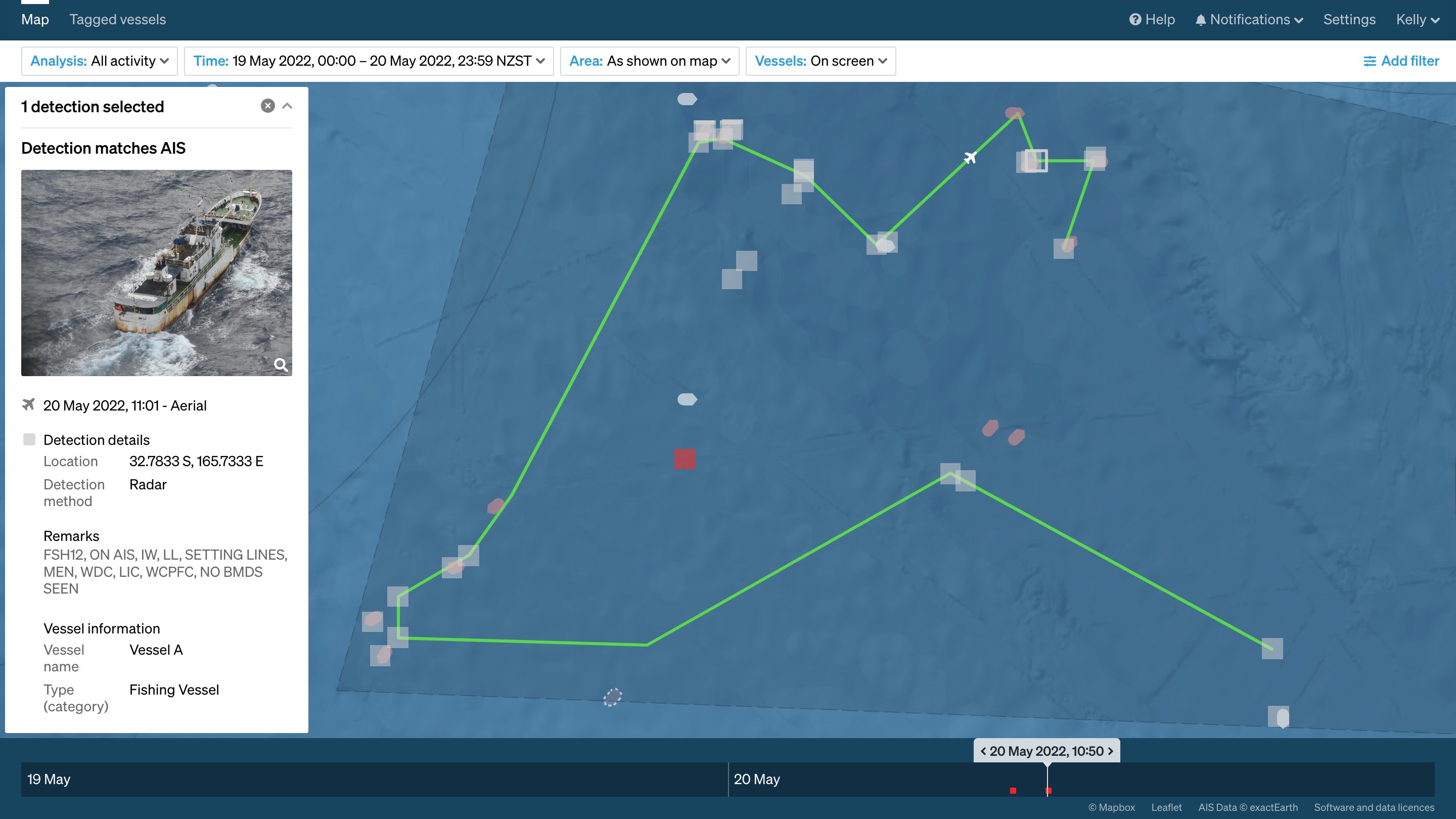
An aerial surveillance patrol flight (green line) validated a radio frequency (RF) scan from Unseenlabs and AIS detections (white squares) and provided photographic evidence of the vessels. TheRF scan from Unseenlabs shows marine navigational radar detections that also matched with AIS positions (white squares). The red square identifies a potential dark vessel, a satellite detection that did not match a known vessel position.
A successful operation
Amassing all this intelligence, the JCC analysis team created a prioritised list of vessels of interest within the Op Nasse area of operations and deployed aerial surveillance and patrol boats to intersect with suspicious vessels.
In total, 18 surveillance flights and 14 high-seas boardings and inspections were carried out. These engagements uncovered 19 potential breaches of WCPFC conservation management measures and at least 8 infringements, with further infringements pending investigations 5.
Infringements included situations where:
- Officers were unable to easily identify shark carcasses and the corresponding fins as required;
- Bycatch mitigation was not deployed correctly;
- Daily catch and effort reporting was not captured accurately; and
- Crew made allegations of poor labour standards 10.
Conclusions and outlook
Averaged over the years 2000 to 2003, the global volume of IUU fishing has been estimated to be between 11 and 26 million tonnes of fish taken annually, corresponding to financial losses between USD10.0 billion and USD 23.5 billion 11. The effect of IUU fishing on ecosystem health, the sustainability of fish stocks, and the economy of individuals, communities, businesses, and coastal states can be devastating 12. In the Pacific, tuna plays a vital role in economic development and, for many states, food security 13, 14.
The scale and complexity of IUU fishing means that no single institution or nation can fight it on its own. International agreements and cooperation can increase the effectiveness of the fight against IUU fishing as demonstrated by Op Nasse over the years. In 2022, analysis and intelligence provided by Megan and other JCC analysts meant assets such as patrol boats and defence force aircraft were able to be used very efficiently and effectively, resulting in positive outcomes that demonstrate the coordinated capabilities and collaborative intelligence-gathering across partner nations.
Technology has an important role to play in this fight. Megan stresses the importance of a common operating picture as being the foundation of effective collaboration. A cloudbased MDA platform facilitates information sharing with minimal latency, enabling command centres such as the JCC and their outposts, including patrol asset operators, to operate 24 hours a day, seven days a week.
Cloud computing also allows access to cutting edge data science and machine learning tools, such as network analysis, at minimal requirements for computing resources by the end user. Specifically, the software-as-a-service model allows rapid co-development of platform features and bespoke analyses with experts at agencies such as AFMA and the Pacific Islands Forum Fisheries Agency. Expert analysts like Megan are central to this development. When their knowledge influences the development of shared systems, it can transfer to others and build capacity where it is needed, thereby creating long-lasting benefits. Then, when software performs the mechanistic portion of Megan’s work, such as determining IUU risk indicators, she can focus on the investigative research and on interpreting the activities in the context of ever changing IUU fishing practices and environmental change.
About the authors
 |
Dr. Moritz Lehmann is an oceanographer and remote sensing scientist who likes to squeeze every little bit of knowledge from ship tracks and vessel behaviour at sea. He leads Starboard’s biosecurity research and supports operations against illegal, unreported and unregulated fishing using satellite dark vessel detections. Moritz is a well-published scientist and a skilled communicator. His work has been featured in several interviews for radio, newspapers and TV. |
|
Megan Charley is a Senior Intelligence Analyst working at the Australian Fisheries Management Authority. Megan has contributed her thought processes and methods for identifying IUU risk to this article. Because indicators alone are not evidence of IUU fishing, Megan must forensically uncover multiple hidden relationships, weigh environmental and geopolitical factors, and collaborate with other analysts to prioritise targets for further investigation. This is illustrated using Megan’s contribution to the successful multilateral anti-IUU fishing Operation Nasse between May and August 2022. |
Learn more in this on-demand webinar
Prioritising vessels for inspection and boarding requires analysts to gather extensive information. In this webinar, Moritz discusses the relationship between technology and expert analysts for determining IUU risk indicators that lead to improved outcomes for operations on the high seas.

Get a demo
References
- Jacobson P. and Gokkon B. 2022. Exclusive: Shark finning rampant across Chinese tuna firm’s fleet. Mongabay Environmental News. https://news.mongabay.com/2022/11/exclusive-shark-finning-rampant-across-chinese-tuna-firms-fleet/
- Brush A. 2019. Strings attached - Exploring the onshore networks behind illegal, unreported, and unregulated fishing. Washington DC: C4ADS.
- MRAG. 2021. The quantification of illegal, unreported and unregulated (IUU) fishing in the Pacific Islands region – a 2020 update. Queensland, Australia: MRAG Asia Pacific.
- Analysis of the WCPFC record of fishing vessels https://www.wcpfc.int/record-fishing-vessel-database
- AFMA (Australian Fisheries Management Authority). 2022. Putting pressure on illegal, unreported and unregulated fishing – a multinational partnership. Canberra: Australian Fisheries Management Authority. https://www.afma.gov.au/news/putting-pressure-illegal-unreported-and-unregulated-fishing-multinational-partnership
- NOAA (National Oceanic and Atmospheric Administration). 2022. September 2022 La Niña update. Washington DC: National Atmospheric and Oceanographic Administration. https://www.climate.gov/news-features/blogs/september-2022-la-ni%C3%B1a-update-it%E2%80%99s-q-time
- Zhou W., Hu H., Fan W. and Jin S. 2022. Impact of abnormal climatic events on the CPUE of yellowfin tuna fishing in the central and western Pacific. Sustainability 14(3):1217.
- Brush A. and Utermohlen M. 2022. Net worth. 45. Washington DC: C4ADS.
- Jakarta Post. 2020. Viral videos show Indonesian crew pleading for help aboard Chinese fishing vessel. Jakarta, Indonesia. https://www.thejakartapost.com/news/2020/08/26/viral-videos-show-indonesian-crew-pleading-for-help-aboard-chinese-fishing-vessel.html
- MPI (Ministry for Primary Industries). 2022. Summary of high seas boarding activities – Operation Nasse 2022. New Zealand Ministry for Primary Industries, Australian Fisheries Management Authority, United States Coast Guard, French Armed Forces New Caledonia.
- Agnew D.J., Pearce J., Pramod G., Peatman T., Watson R., Beddington J.R. and Pitcher T.J. 2009. Estimating the worldwide extent of illegal fishing. PLOS ONE 4(2): e4570. https://doi.org/10.1371/journal.pone.0004570
- FAO (Food and Agriculture Organization). 2002. Implementation of the international plan of action to prevent, deter and eliminate illegal, unreported and unregulated fishing. 122. Food and Agricultural Organization of the United Nations, Rome, Italy.
- Bell J.D., Senina I., Adams T., Aumont O., Calmettes B., Clark S., Dessert M., Gehlen M., Gorgues T., Hampton J., Hanich Q., Harden-Davies H., Hare S.R., Holmes G., Lehodey P., Lengaigne M., Mansfield W., Menkes C., Nicol S., Ota Y., Pasisi C., Pilling G., Reid C., Ronneberg, E., Gupta A.S., Seto K.L., Smith N., Taei S., Tsamenyi M. and Williams P. 2021. Pathways to sustaining tuna-dependent Pacific Island economies during climate change. Nature Sustainability 4:900–910.
- Terawasi P. and Reid C. 2017. Economic and development indicators and statistics: Tuna fisheries of the western and central Pacific Ocean. Honiara, Solomon Islands: Pacific Islands Forum Fisheries Agency.

