Global maritime domain awareness and vessel analysis
ReleasesLearn about our latest improvements
Arming research analysts with hidden clues to their maritime domain
Global maritime domain awareness and vessel analysis
ReleasesLearn about our latest improvements
Arming research analysts with hidden clues to their maritime domain
Fisheries monitoring and surveillance
Turning data into insights for effective fisheries monitoring and uncovering hidden IUU fishing
Starboard Maritime Intelligence is intuitive web-based software ideal for fisheries monitoring. It helps analysts identify which vessels to inspect and why.
Protecting our oceans is a shared responsibility between flag states, coastal states and port states. Starboard supports governments, fisheries organisations, RFMOs and NGOs by bringing people and multiple sources of data together to improve collaboration.
Insights for efficient inspections of fishing vessels
Analyse fishing specific activity since last port of call to compare with log books
Starboard analyses automatic identification system (AIS) data and creates vessel histories that highlight significant events, such as fishing activity, port visits, when two vessels meet at sea, and vessel detections in satellite data and from surveillance assets.
This enables fisheries officers to quickly check noteworthy events since the last port of call, making it easy to verify self-reported events, such as transshipments.
Real-time information in the hands of fisheries officers
Starboard works on any device with an internet connection, enabling critical information to be accessed by a frontline staff member with a mobile device.
Any view in Starboard can be shared or saved by copying and pasting the URL, enabling officers to review and share the exact vessel, activity, and location quickly and accurately without the need to email screenshots, or download and manage complex data.
AIS data analysis built for fisheries analysts
The world’s most comprehensive AIS data
We continually ingest both satellite and terrestrial AIS data from exactEarth.
Managing a large volume of global AIS is a complex big data challenge. We’ve overcome this with a mix of proprietary and open source algorithms and machine learning models.
Turning AIS data into fisheries insights
Fishing activity can be broken down by flag state and is available for real-time and historical analysis, letting you see what’s happening now and understand year-on-year change. Encounters between vessels are also highlighted which may signify exchange of fish, fuel, cargo, or people.
Buoys using AIS transponders are detected and hidden by default, reducing noise. However, these can be turned on to track the movement of fishing equipment and in some cases uncover the movement of non-reporting, or ‘dark’ fishing vessels.
A collaborative common operating picture to support operations
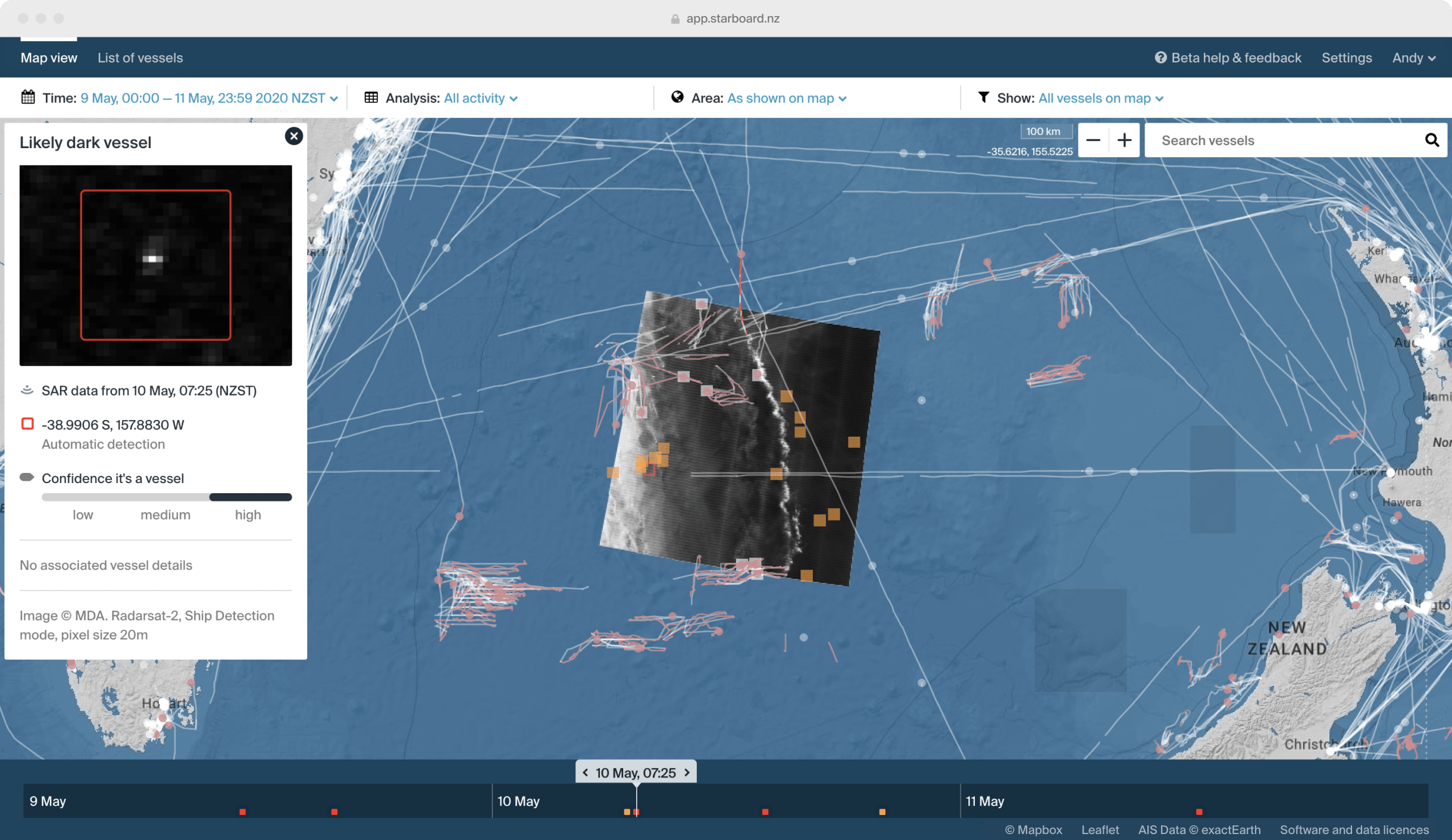
Using satellite data for dark vessel detection
To provide a complete picture of both reporting and dark vessels in your area of interest we use additional satellite data. We combine these data sources in near real-time with AIS locations to detect dark vessels at sea, and indicate areas for further investigation. We’re data agnostic and focus on using the most appropriate information for the challenge at hand.
Ensuring assets are effectively used during an operation
Knowing when and where to deploy aerial and on the water assets can improve the impact of a maritime surveillance operation. Using Starboard we study historical fishing patterns and vessels of interest to know where it is best to not only task satellite acquisitions but also where it is best to deploy on the water and aerial assets.
Ingesting data from operation assets to tell the whole story
Data from both aerial and on the water assets is layered with satellite and AIS data. Photos and observation notes from assets are ingested into Starboard, creating rich vessel histories which lead to a better understanding of vessels in your areas of interest.
Bringing dispersed teams and disparate data together
Teams in different locations can share the exact same geospatial intelligence picture including data from satellites, assets and AIS. Starboard provides a shared platform which is invaluable when several teams, government agencies or even countries are involved.
Extend Starboard with custom risk models and your data
Co-develop new risk assessment models
We have a cross-functional team of scientists and engineers that co-develops risk assessment models with customers, which are then integrated into Starboard. The above example shows biosecurity risk models for the New Zealand government. In fisheries, for example, we could co-develop a model to evaluate fishing registration details against areas of fishing activity.
Add your organisational data to Starboard
We work in a private and secure domain, meaning organisations can bring their data into Starboard and it is only available to them. Through co-development we can set up automatic processes to ingest both one off data, and continuous data like fisheries’ vessel monitoring system (VMS) data.
Flexible pricing and plans to suit
Releases →
Meet the team →

