Global maritime domain awareness and vessel analysis
ReleasesLearn about our latest improvements
Arming research analysts with hidden clues to their maritime domain
Global maritime domain awareness and vessel analysis
ReleasesLearn about our latest improvements
Arming research analysts with hidden clues to their maritime domain
Combining vessel authorisations, vessel information, and vessel positions for port state measures
Case Study · 25 July 2023 · 10 minute read
Analysing vessel histories and RFMO vessel lists to support decision making on port use and inspection prioritisation
Port State Measures (PSM) and Catch Documentation Schemes (CDS) are both specifically designed to stop fish caught through illegal, unreported, or unregulated (IUU) fishing from entering the supply chain 1. These complementary measures rely heavily on the port states, flag states, and coastal states for effective implementation. Vessel positions, licences, and authorisations are key pieces of information to assess vessel compliance during events like harvesting, transshipping, and landing.
Table 1: Supply chain function by state
| State | Coastal | Flag | Port | Processing | Market |
|---|---|---|---|---|---|
| Harvesting | ✓ | ✓ | |||
| Transshipping | ✓ | ✓ | ✓ | ||
| Landing | ✓ | ✓ | ✓ | ||
| Transport to processing | ✓ | ✓ | |||
| Processing | ✓ | ||||
| Importation | ✓ |
Effective compliance requires multilateral coordination throughout the supply chain. For example, flag states need to have oversight for critical tracking events of harvesting, transshipment of catch (both for the receiving and donor vessels), and unloading of catch. The FAO voluntary guidelines for transshipment build on the primary responsibility of flag states and also include the roles and responsibility of coastal states, port states, and RFMOs 2. Port states are responsible for critical events of landing of catch and transshipment if it occurs within their ports 3.
PSMs generally extend the responsibility of the port all the way back to harvesting 4, reflecting the port’s critical role in the supply chain. This is because fish do not become illegal in a factory, they are caught and landed illegally and the port is the conduit between the land and the sea 5.
Ports are so critical in the supply chain and in IUU prevention that, under the Port State Measures Agreement (PSMA), this extension of responsibility goes beyond just landing fish and includes any use of ports for any foreign flagged fishing vessel or support vessels—this includes bunkers and fish carriers that undertake fishing related activities 6.
However when fishing vessels, flagged to distant water fishing nations, operate far from their home jurisdiction and visit foreign ports for landing or transshipment, effective implementation of PSMs can be a challenge. Multilateral collaboration between RFMOs, port states, coastal states and flag states is the most important element of effective implementation. Access to relevant data and the smooth exchange of information between these parties is critical.
| Implementing port state measures |
The PSMA entered into force in June 2016 and currently 74 countries are party to the agreement 8. Several countries that are not party to the PSMA also have robust PSM in place, for example all members of Pacific Islands Forum Fisheries Agency (FFA) work towards the FFA Regional PSM Framework 11. Similarly the Western and Central Pacific Fisheries Commission (WCPFC) works towards a minimum standards Approach 12, this framework means consistent action is taken in ports without transferring a disproportionate burden on developing nations. |
Key data element: Vessel authorisation and licences
To assist in the exchange of authorisation information all 13 Regional Fisheries Management Organisation (RFMO) maintain a publicly available register of vessels that are authorised to fish in their area of management 13. These lists include fishing vessels as well as support vessels such as bunkers and carriers, and contain vessel details that are essential for managing compliance such as:
- Vessel ownership and personnel information
- Vessel type (e.g. longliner, fish carrier, purse seiner)
- Identifying information (e.g. vessel name, MMSI, identifying markers, photos)
- Vessel characteristics (e.g. tonnage, hull material, length, engine power)
- Vessel equipment (e.g. fish hold capacity, freezers, gear, navigation systems)
- Authorisation (e.g. high seas transshipment, time period, species, area)
- Vessel history (e.g. previous flags, names, ports of registry)
- Charter information (e.g. charter name, charter period)
A global view of the 13 RFMO lists, along with other authorisation lists such as the EU Fleet Register and FFA List of Vessels in Good Standing, is available in Starboard.
Authorisation to fish in a coastal state’s EEZ, that is not the same as the vessel’s flag state, is generally not required by the flag state 3. When this authorisation lies solely with the coastal state this can lead to an information gap which can impact the flag state’s ability to live up to its legal responsibilities 14, FAO’s Voluntary Guidelines on Flag State Performance 15, and makes information hard to verify for port states. In addition, coastal state authorisation lists are not consistently published publicly like RFMO authorisations.
There are exceptions to this:
- EU vessels fishing in the EEZ of non-EU countries require authorisation by their flag state to do so. These authorisations are also publicly available the European Commission website 16.
- The Pacific Island Forum Fisheries Agency (FFA) also maintains a list of good standing which is used as a precursor to coastal state licensing. If a vessel is not on the FFA List of Vessels in Good Standing then they won’t be legally allowed to fish in one of the FFA’s 17 member states EEZs 17.
Vessel licences are issued by the flag state and it is the flag state’s responsibility to maintain and communicate these for port state measures and catch documentation schemes. Some countries publicly publish their vessel registries including Australia, Chile, Costa Rica, Iceland, Malaysia, Russia, United States, Canada, Taiwan, Faroe Islands, Republic of Korea, and Norway 18. Although these country specific registrations generally don’t include authorisations to fish an exception to this is the Faroe Islands which includes licence and quota information for both RFMOs and EEZs.
Key data element: IUU lists
RFMOs also all maintain lists of vessels who have engaged in IUU fishing 13. Trygg Mat Tracking (TMT) has consolidated these lists into the Combined IUU List, a valuable resource of up to date IUU listed and previously listed vessels.
IUU listed vessels, previously listed vessels, and vessels that have close on-water networks to them are available as a global tag in Starboard which can be used to find noteworthy vessels in an area.
Key data element: Vessel positions and harvesting activity
This is the most dynamic area of data and includes real-time vessel positions from vessel monitoring systems (VMS) and Automatic Identification Systems (AIS). These systems allow administrations to follow the movements of fishing vessels and cross-check these positions with what is reported by vessel masters, for example in logbooks, port arrival information, and catch certificates 3.
Logbooks can be both written and electronic and require masters to record locations and times of harvesting, estimates of how much is harvested, what species are harvested, and what gear was used. They also need to record transshipment information and electronic logbooks can be integrated with VMS systems 19.
Indicators for inspection planning
Vessel position information, manoeuvring analysis, IUU lists, and authorisations are of course not the only data requirements for PSM (and potentially CDS). The volume of data required can make it challenging for teams to sort through and find the highest risk or non-compliant vessels to focus inspection efforts on.
Risk analysis based on vessel behaviours and characteristics can help to filter through large volumes of information and support the decision to either deny port access, inspect a vessel once it is in port, or determine what might require the closest scrutiny during the inspection.
The Marshall Island Marine Resources Authority (MIMRA) as part of their PSM best practices 20 imposes strict timeframes for vessels to announce their intention to enter port and uses this time to gather intelligence. Their intelligence analysis and risk determination allow for the identification of risks in three different categories corresponding to three steps in the analysis, including:
- Identity – whether the vessel is who it says it is,
- Manoeuvring – the vessel’s activity and operations and whether these were adequately reported, and
- Licensing – whether the vessel is allowed to fish in the location it was.
The risk analysis performed by MIMRA is focused on fishing vessels to assess the legality of the catch and on carriers’ activities not directly related to transshipments.
They may for example identify an inferred transshipment or long loitering periods which could indicate a potential vessel encounter. These occurrences can be assessed and then investigated during boarding, by verifying if has been recorded in the logbook and/or by checking if the temperature records for the holds varied during these pre identified periods 21.
Fish carriers and bunkers create network complexity
Some of the most complicated vessel histories are from those vessels that support fisheries operations. When these vessels arrive in a port, the PSM means their history between port visits and their network of encounters needs to be reviewed to assess if they have been involved in IUU fishing or fishing related-activities that support IUU fishing 4.
The harvesting activity of the fishing vessels these carriers have met should also be assessed and the vessel’s fishing authorisations for the area they are harvesting in confirmed. If harvesting is in an RFMO high seas area this can be checked with the RFMO authorisation list. If the harvesting has occurred in an EEZ that is not the vessel’s flag state EEZ then bilateral communication between the coastal and flag state is required to confirm authorisation 4.
Global systems to share information are under continued development and include the FAO Global Information Exchange System (GIES) and FAO Global Record of Fishing Vessels, Refrigerated Transport Vessels and Supply Vessels.
Collaboration is critical for information sharing
Intelligence gathering and interpreting vessel behaviours can require detailed understanding and expert analysis. Behaviour that may at first seem perplexing could for example simply be explained by weather conditions. At other times this behaviour may indicate IUU fishing behaviour. Understanding not only the data but also the detailed conservation management measures of an area is needed to interpret this behaviour further.
This is not a job best done alone. Multilateral collaboration and data sharing across experienced analysts, industry experts and enforcement agencies are needed in order to create impactful action to stop IUU fishing.
Webinar
Learn more about Starboard developments to support complex analysis on a global scale and how the integration of RFMO lists can support port state measures in this webinar recording.

Get a demo
Learn more about Starboard for fisheries analysis and investigations.
References
- FAO. (2017). Voluntary Guidelines for Catch Documentation Schemes Poster. https://www.fao.org/3/i7308e/i7308e.pdf
- FAO. (2023). Voluntary Guidelines for Transshipment. FAO. https://doi.org/10.4060/cc5602t
- Hosch, G., & Blaha, F. (2017). Seafood traceability for fisheries compliance: Country-level support for catch documentation schemes. http://www.fao.org/3/i8183en/i8183en.pdf
- The Pew Charitable Trusts. (2017). Implementing the Port State Measures Agreement. https://www.pewtrusts.org/-/media/assets/2017/04/capacity_needs_assessment.pdf
- Blaha, F. PSM Implementation in the Marshall Islands. (2021). https://www.youtube.com/watch?v=lAVKAT-tCk8
- Under the PSMA the term “fishing related activities” is stated as “any operation in support of, or in preparation for, fishing, including the landing, packaging, processing, transhipping or transporting of fish that have not been previously landed at a port, as well as the provisioning of personnel, fuel, gear and other supplies at sea”. FAO. (2016). Agreement on Port State Measures to Prevent, Deter and Eliminate Illegal, Unreported and Unregulated Fishing. https://www.fao.org/3/i5469t/I5469T.pdf
- AFMA. (2023). Toothfish | Australian Fisheries Management Authority. https://www.afma.gov.au/species/toothfish#referenced-section-7
- FAO. (2016). FAO Treaties Database. https://www.fao.org/treaties/results/details/en/c/TRE-000003/
- CCAMLR. (2017). Catch Documentation Scheme (CDS). https://www.ccamlr.org/en/compliance/catch-documentation-scheme
- CCAMLR. (2022). Membership. https://www.ccamlr.org/en/organisation/who-involved-ccamlr
- Pacific Islands Forum Fisheries Agency (FFA). (2020). FFC adopts the FFA Regional PSM framework. https://www.ffa.int/node/2454
- Manarangi‐Trott, L. (2021). Port State Measures The WCPFC Minimum Standards Approach. https://www.mpi.govt.nz/dmsdocument/46633-Port-State-Measures-The-WCPFC-Minimum-Standards-Approach
- Camilleri, M., & Mosteiro, Alicia. (2021). Workshop on Implementation of Port State Measures. https://www.mpi.govt.nz/dmsdocument/46630-APEC-Workshop-Port-State-Measures
- UNCLOS ARTICLE 94. Duties of the flag State. Every State shall effectively exercise its jurisdiction and control in administrative, technical and social matters over ships flying its flag. https://www.un.org/depts/los/convention_agreements/texts/unclos/part7.htm
- FAO. (2015). Voluntary Guidelines for Flag State Performance. https://www.fao.org/3/I4577T/i4577t.pdf
- European Commission. (n.d.). Fishing outside the EU. Retrieved May 9, 2023, from https://oceans-and-fisheries.ec.europa.eu/fisheries/international-agreements/fishing-outside-eu_en
- Blaha, F. (2019). The FFA register of vessels of “good standing” is online. http://www.franciscoblaha.info/blog/2019/4/2/the-ffa-register-of-vessels-of-good-standing-is-on-line
- Park, J., Van Osdel, J., Turner, J., Farthing, C. M., Miller, N. A., Linder, H. L., Ortuño Crespo, G., Carmine, G., & Kroodsma, D. A. (2023). Tracking elusive and shifting identities of the global fishing fleet. Science Advances, 9(3). https://doi.org/10.1126/sciadv.abp8200
- FAO. (n.d.). Logbooks and VMS | Coordinating Working Party on Fishery Statistics (CWP). Retrieved May 9, 2023, from https://www.fao.org/cwp-on-fishery-statistics/handbook/capture-fisheries-statistics/logbooks-and-vms/en/
- Marshall Islands Marine Resources Authority (MIMRA). (n.d.). Port Entry. Retrieved July 3, 2023, from https://www.rmimimra.com/index.php/about-us/oceanic-industrial-affairs/port-entry
- Blaha, F. (2021). PSM Implementation in the Marshall Islands. https://www.mpi.govt.nz/dmsdocument/46624-PSM-Implementation-in-the-Marshall-Islands-Franscisco-Blaha
Read more
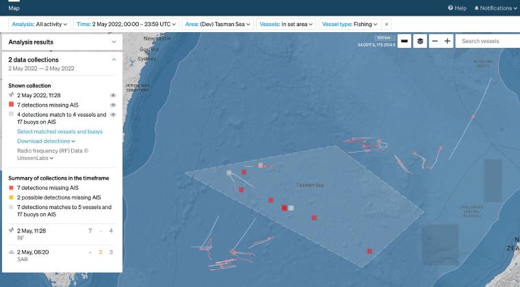
CASE STUDY
In May 2020 Starboard set out to provide an enhanced picture of southern bluefin tuna fisheries in the Tasman Sea. Combining real-time AIS with vessel detections by satellite for surveillance in this area of interest.
Read case study →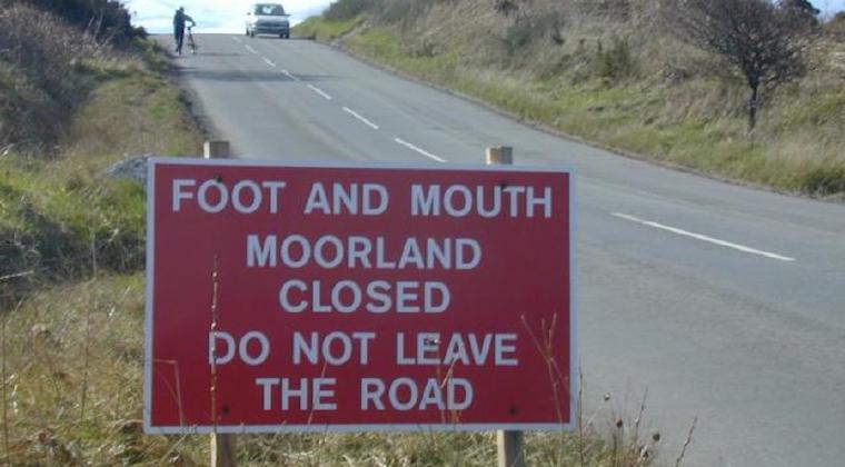
CUSTOMER CASE STUDY
Flagging vessels with heightened risks, such as foot and mouth disease, supports the planning and processes for border teams
Read case study →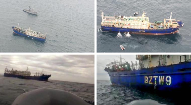
CUSTOMER CASE STUDY
Sabina Goldaracena is a custodian of the South West Atlantic maritime domain. She connects the clues in her investigations, uncovers hidden activity and works towards transparency by sharing her stories.
Read case study →
