Global maritime domain awareness and vessel analysis
ReleasesLearn about our latest improvements
Arming research analysts with hidden clues to their maritime domain
Global maritime domain awareness and vessel analysis
ReleasesLearn about our latest improvements
Arming research analysts with hidden clues to their maritime domain
Satellite surveillance demonstration
News · 19 October 2023
Global tech providers to host satellite surveillance exercise focused on smuggling at sea
Starboard Maritime Intelligence, S&P Global Market Intelligence, Spire Maritime, and Planet Labs PBC are collaborating to demonstrate emerging technology and tools that help combat illegal smuggling of commodities. The showcase will take place at the Indo Pacific 2023 Maritime Exposition, 7-9 November in Sydney Australia, and will also be available live online.
The exercise called Operation TS will focus on using maritime domain awareness tools, vessel information, and satellite imagery to uncover behaviours associated with illegal smuggling.
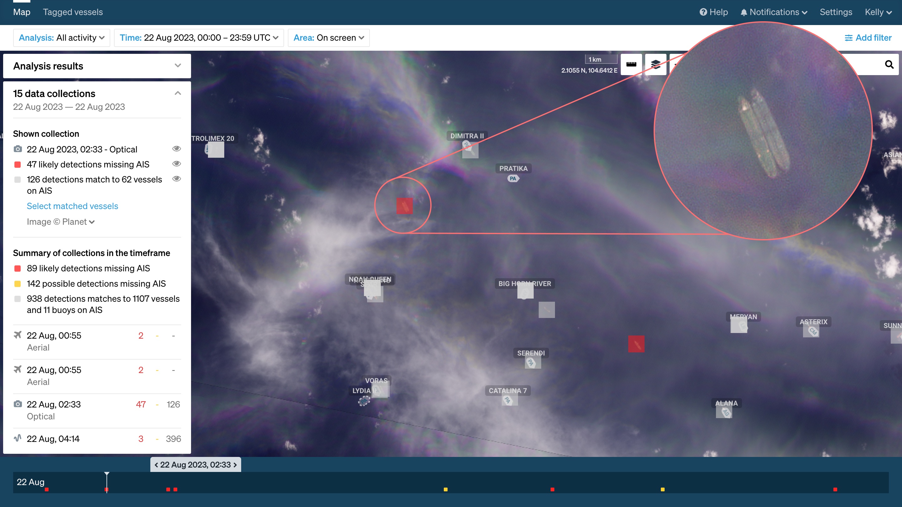
Planet imagery in Starboard showing dark vessels undertaking ship to ship transfer activity.
“Techniques for smuggling are becoming increasingly sophisticated and analysts routinely need to employ multiple approaches to uncover this activity which can include ship to ship transfers, turning off location reporting, behaving in anomalous ways, location spoofing, flying flags of convenience, and using multiple layers of shell companies,” says Mat Brown, CRO, Starboard.
S&P Global Market Intelligence recently released a report which highlighted the growth of the Russian tanker shadow fleet currently sidestepping G7 oil price caps. This fleet is estimated at 443 vessels, many of which are older vessels that run risks ranging from crew health and safety, to oil spills and collisions, to operating without adequate insurance due to non-compliance with sanctions.
Starboard is blending S&P Global Market Intelligence data with vessel behaviour algorithms including those that predict possible vessel movements and port visits when a vessel has gone dark. The S&P Global Market Intelligence vessel database contains over 600 fields of information on vessels with an International Maritime Organisation (IMO) number and provides insights on ownership structures, ownership changes, and vessel management.
“Maritime domain awareness tools that allow analysts to understand the complex network of relationships, via at sea encounters and ownership structures, can help to uncover high risk vessels and fleets,” says Brown.
Illegal operators often rely on hiding their activity by turning off their AIS devices or spoofing their locations. A recent example highlighted vessels spoofing their location so that they appeared to load oil from the United Arab Emirates whilst actually loading oil in Iran–an activity that would violate sanctions. This kind of spoofing activity can be uncovered by emerging tools like Spire’s AIS Position Validation. Electro optical satellite imagery from high resolution commercial provider Planet Labs, can then be utilised to capture images with enough detail for these vessels to be identified in their actual locations.

Satellite image of the Monomakh, a vessel allegedly engaged in transporting sanctioned oil to Russia according to the Wall Street Journal. © 2022, Planet Labs PBC.
“What the community has historically talked about as a futuristic potential ability is now here, being used across the globe to solve the challenges of dark vessels. At Planet, we capture daily satellite data of the Earth, allowing analysts to monitor vessels in almost real time and identify dark vessels by their prior trajectory and dimensions. We are now in a moment where our satellite data is allowing customers to go from identifying only a fraction of dark vessels through reports to seeing thousands of ships across broad areas and through time,” says Mike Merit, Planet Chief Customer Officer.
The live showcase held at the Indo Pacific 2023 Maritime Exposition will also be available online with daily updates. Technology from all four providers will demonstrate how new tools are helping organisations ranging from defence to insurance in uncovering complex and evolving illegal activity at sea.
Register for Operation TS
Register for the online demonstration and updates or to meet the team at Indo Pacific 2023.
About Starboard Maritime Intelligence
Starboard supports governments, border security teams, NGOs and fisheries organisations to navigate the vast amounts of maritime data available enabling them to make better decisions about which vessels to focus on and inspect. Starboard is a subscription based platform that combines global automatic identification system (AIS) data, multiple layers of satellite data, scientific models, machine learning models, vessel information from S&P Global Intelligence, and other information or intelligence. Starboard was developed with funding from the New Zealand Ministry of Business, Innovation and Employment (MBIE). To learn more visit www.starboard.nz.
About Planet Labs, PBC
Planet is a leading provider of global, daily satellite imagery and geospatial solutions. Planet is driven by a mission to image the world every day, and make change visible, accessible and actionable. Founded in 2010 by three NASA scientists, Planet designs, builds, and operates the largest Earth observation fleet of imaging satellites. Planet provides mission-critical data, advanced insights, and software solutions to over 900 customers, comprising the world’s leading agriculture, forestry, intelligence, education and finance companies and government agencies, enabling users to simply and effectively derive unique value from satellite imagery. Planet is a public benefit corporation listed on the New York Stock Exchange as PL. To learn more visit www.planet.com and follow us on Twitter.
About Spire Maritime
Spire (NYSE: SPIR) is a global provider of space-based data, analytics and space services, offering unique datasets and powerful insights about Earth so that organizations can make decisions with confidence in a rapidly changing world. Spire builds, owns, and operates a fully deployed satellite constellation that observes the Earth in real time using radio frequency technology. The data acquired by Spire’s satellites provides global weather intelligence, ship and plane movements, and spoofing and jamming detection to better predict how their patterns impact economies, global security, business operations and the environment. Spire also offers Space as a Service solutions that empower customers to leverage its established infrastructure to put their business in space. Spire has nine offices across the U.S., Canada, UK, Luxembourg, Germany and Singapore. To learn more, visit spire.com.
Read more
NEWS
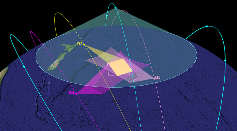
Starboard, MDA and Unseenlabs to host live satellite surveillance demonstration targeting illegal fishing
Read media release →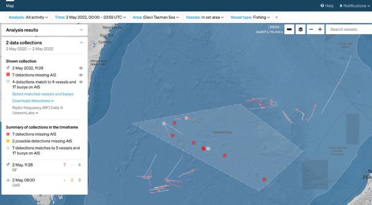
CASE STUDY
In May 2020 Starboard set out to provide an enhanced picture of southern bluefin tuna fisheries in the Tasman Sea. Combining real-time AIS with vessel detections by satellite for surveillance in this area of interest.
Read case study →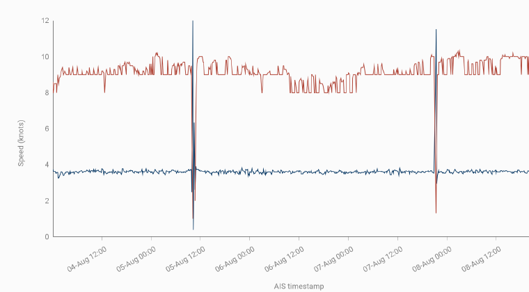
CASE STUDY
Amongst the millions of ship positions, how can we find movements that are not normal? How can we find anomalous movements leading to the discovery of vessels that might be noteworthy and need further investigation?
Read case study →
