Global maritime domain awareness and vessel analysis
ReleasesLearn about our latest improvements
Arming research analysts with hidden clues to their maritime domain
Global maritime domain awareness and vessel analysis
ReleasesLearn about our latest improvements
Arming research analysts with hidden clues to their maritime domain
Detecting non-reporting vessels
News · VAIAKU (Tuvalu) · 10 August 2022
Satellites used to search for illegal fishing in Tuvalu’s waters
- Satellites were tasked to scan Tuvalu’s exclusive economic zone to detect non-reporting vessels.
- These satellites use new cutting-edge technology that significantly enhances fisheries monitoring, control and surveillance capabilities in collaboration with regional organisations/bodies.
- This technology is closing the surveillance gap for large ocean areas, the plan being to reduce the millions lost to illegal, unreported and unregulated fishing.
Nearly 60 satellite scans of Tuvalu’s exclusive economic zone (EEZ) have been obtained since December 2021 as part of a pilot project under the World Bank-funded Pacific Islands Regional Oceanscape Program (PROP). This initiative, designed to chart the extent of fishing activity by non-authorised or non-reporting vessels, is a collaboration between the Tuvalu Government’s Fisheries Department and New Zealand company Starboard Maritime Intelligence.
Fisheries are of critical importance to the region. Illegal, unreported and unregulated (IUU) fishing for tuna in the Pacific region is estimated to amount to almost 200,000 tonnes per year. For many Pacific Island nations the licence fees from vessels fishing in their EEZ is a major part of their annual income.
“What Tuvalu is doing here is important, because access fees paid by foreign vessels fishing their waters represent more than fifty-five percent of government revenue,” says fisheries compliance advisor, Francisco Blaha, who has worked in Pacific Island fisheries for over 30 years and collaborated with Starboard in this project. “Anyone fishing illegally causes a direct hit to the economic viability of the country.”
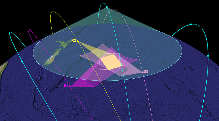
Each satellite scan, covering up to eighty percent of Tuvalu’s EEZ (750,000 km2), uses cutting-edge technology and is applied for the first time in this region. Different types of satellite sensors are used and provide independent means of detection, including mapping the locations of navigational radars aboard ships, and imaging of the ocean surface using synthetic-aperture radar.
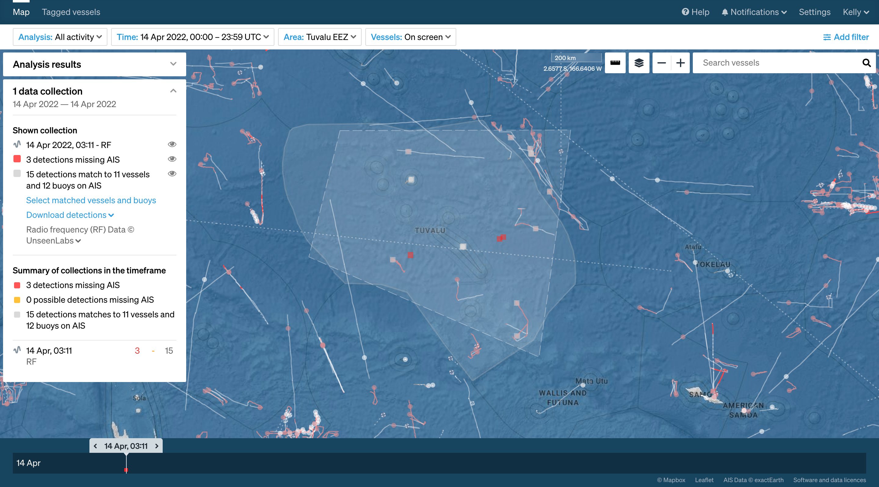
Starboard Maritime Intelligence showing RF detections of potential dark vessels (red spots) in the Tuvalu EEZ. The large footprint (quadrangle) of satellite RF detection means that a single data acquisition during an overpass can cover up to 80% of Tuvalu’s vast EEZ (750,000 km2).
Satellite detections and the positions of known vessels are automatically matched in the Starboard digital platform. Any vessels detected that are not also reporting their locations using the mandated identification systems are highlighted as being ‘dark’ – that is, potentially fishing illegally in the area and trying to evade identification.
“Most of our scans in Tuvalu contained some potentially dark vessels. We found that their number varied quite a bit over time just as licensed activity is variable,” says Principal Fisheries Officer at Tuvalu Fisheries Department, Tupulaga Poulasi.
The scale of the operation and the use of new technology has rallied others in the region. For example, the Pacific Island Fisheries Forum Agency (FFA) and New Zealand Defence Force (NZDF) provided additional intelligence including verification of scans from air and sea patrols.
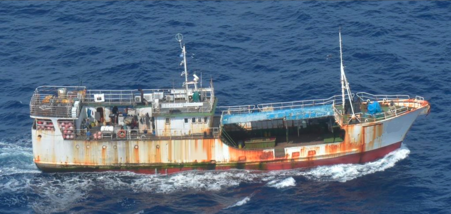
Typical long-liner vessel operating in the Tuvalu EEZ. Photo obtained by the New Zealand Defence Force during a patrol flight in May 2022.
“Satellite reconnaissance is due to become a regular tool for us to learn about the patterns of dark vessel activity, which supports our intelligence analysis work on key high-risk areas and targets to direct surface and air assets,” says FFA Surveillance Operations Officer, Yohni Fepuleai.
Supporting Pacific Island countries such as Tuvalu to harness the potential of their natural resources, especially fisheries, in a sustainable way lies at the heart of poverty reduction. “Combating illegal fishing through conventional approaches, supported by technology such as satellite monitoring, is key to achieving this goal,” said World Bank Senior Natural Resource Management Specialist and team leader for the PROP project, Iretomiwa Olatunji.
Although these new technologies and the merging of different types of data can significantly enhance fisheries monitoring, control and surveillance (MCS), there is a steep learning curve in understanding and exploiting what they offer. The project team is working on instructional resources and is planning a workshop to build local capability and to share the learnings from this project. Practitioners are invited to register their interest for more information from today →
“Regional collaborations, like this operation, support ongoing research as we see a rapid increase in new technology in this area,” says Starboard Maritime Intelligence’s Senior Scientist, Dr Moritz Lehmann. “Over the past year or so more than a dozen new commercial vessel-detection satellites have come online, and before the end of 2023 we expect dozens more, which means we are quickly closing the surveillance gap.”
MCS practitioner registration of interest
Learn more about the challenges and opportunities of satellite surveillance for fisheries, the importance of cross-region collaboration, capability building, and the evolution of satellite detection technology.
The Pacific Regional Oceanscape Program (PROP)
PROP is a World Bank-funded program supporting the Federated States of Micronesia, Kiribati, the Marshall Islands, the Solomon Islands, Tonga and Tuvalu to strengthen their management of oceanic and coastal fisheries. PROP provides the basis for sustainable, increased economic benefits to these nations from fisheries. Learn more about PROP.
More about the Tuvalu Fisheries Department
Tuvalu is situated in the Pacific Ocean just south of the equator. The islands, all low- lying atolls, occupy 26 km2 of their 750,000 km2 EEZ. Tuvalu is home to around 11,000 people. The Tuvalu Fisheries Department’s mission is to maximise social and economic returns to the people of Tuvalu through the sustainable management and wise use of the nation’s living marine resources. Learn more about the Tuvalu Fisheries Department.
More about Francisco Blaha
Francisco is a fisheries biologist with over 30 years of operational fisheries experience in the Western and Central Pacific Ocean (WCPO). Working initially as a fisher, he has transitioned into a researcher, trainer, compliance and monitoring, control and surveillance (MCS) adviser for over 20 international organisations, governments, NGOs, technology providers, and industry groups across 55 countries. Learn more about Francisco.
More about Starboard Maritime Intelligence and Xerra
Starboard supports governments, border security teams, NGOs and fisheries organisations to navigate the vast amounts of maritime data available from satellite sensors, and focus on the vessels that matter to them. Starboard has been developed by Xerra Earth Observation Institute which has been established with funding from the New Zealand Ministry of Business, Innovation and Employment (MBIE). Learn more about Starboard.
Read more
NEWS
Starboard, MDA and Unseenlabs to host live satellite surveillance demonstration targeting illegal fishing
Read media release →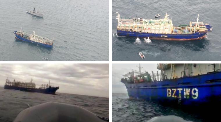
CUSTOMER CASE STUDY
Sabina Goldaracena is a custodian of the South West Atlantic maritime domain. She connects the clues in her investigations, uncovers hidden activity and works towards transparency by sharing her stories.
Read case study →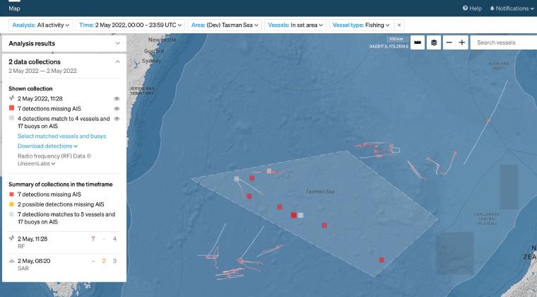
CASE STUDY
In May 2020 Starboard set out to provide an enhanced picture of southern bluefin tuna fisheries in the Tasman Sea. Combining real-time AIS with vessel detections by satellite for surveillance in this area of interest.
Read case study →
